Description of the components of the nominated property

Imatge

Delimitation criteria

The representative areas that comprise the components parts of the nominated property have been established on the basis of a broad work of research and scientific, administrative and community discussion aimed at locating a complete representation of all the significant values and attributes of the property, in different spaces that, as a whole, express and transmit its Outstanding Universal Value.

After exhaustively identifying the values hosted by the property, a comparative analysis of its main attributes (see Sec. 3.2), and confirming the application criteria (see Sec. 3.1.b), the delimitation of the components parts is the result of depicting them in territorial areas resulting from the commitment to apply the following additional criteria:


1. Representativeness of Menorcan Cyclopean constructions and their outstanding expressions 
2. Density and diversity of sites
3. Quality and representativity of the landscape environments 

4. Symbolic references and landmarks of the landscape
5. Techniques and uses of the territory
6. Association with vestiges of material culture
7. Connectivity and inter-visibility
8. Integrity and authenticity
9. Protection


Thus, the nominated property takes the form of a serial cultural property organised into nine territorial areas or components, resulting from the application of the aforementioned criteria. 

Description of the components parts

The maps covering the components of the nominated serial property show that practically all of them are located in the “Migjorn”, the Miocene limestone platform of the south of Menorca, the preferred space of the ancient peoples that settled the island, except for one (C9), to the north-east of the “Tramuntana”, representative of the prehistoric settlements of this northern part of the island. The total area of the serial property accounts for practically 5% of the area of the island and, altogether, hosts 280 prehistoric archaeological sites - 21% of all the archaeological sites on the island.


Component C1: Plains of Ciutadella (Es Tudons, Torretrencada and Torrellafuda)
alt textDescription, location and setting
It is situated in the west of Menorca, in an area known as Llanos de Ciutadella, in the municipality of the same name. These are flat lands, set in the karstic clay depressions of this part of the island, home of the most sought-after lands for farming and grazing since prehistoric times. The exceptional fertility and good drainage of these plains explains why they remain one of the most agriculturally rich landscapes of the Migjorn even today.
The landscape shows the distinctive traits of the Menorcan agroforestry mosaic, albeit with a greater presence of grazing and forage crops here because of the fertility of the soils, which alternate with patches of natural vegetation comprised of wild olive maquis and mastic trees, dotted with holm oak and pine stands. The importance and high biological and ecological value of these forestry formations has meant that a large area that surrounds the villages of Torrellafuda and Torretrencada is considered a habitat of Community Interest (EU Habitat Directive, 1992).
The farms are bounded by the traditional grid of dry stone walls and include many auxiliary buildings associated with the art of dry stone walling. The area is half way between two significant landscape units of the island: the “grazing plains of northern Ciutadella” and the “farming plains of southern Ciutadella” (PTIMe, 2003).
It is a place with an extremely high density of archaeological sites, with 36 recorded sites in an area of 440 ha. The remains of three prehistoric settlements, (Torrellafuda, Torretrencada and Es Tudons) are located in this area. There are also four “talayots” that weave a web of intervisibility closely connected with other talayots of this part of the island.
Two of these settlements are home to unique architectural remains found exclusively on Menorca. The Talayotic village of Torretrencada stands apart for hosting one of the most spectacular taulas of Menorca, made unique by its adjoining pilasters, on top of the  fact that this settlement remained inhabited in Roman and Islamic times. Taula enclosures and the remains of monumental circular houses can also be identified at the spectacular site of Torrellafuda, one of the great walled settlements of the Late Talayotic period. The large dimensions of the slabs give us an idea of just how monumental these structures must have been, and they remained in use up to Islamic times.
This component contains interesting vestiges of ancestral water engineering, including catchment systems, canals excavated into the rock and wells. In terms of the relationship between water and settlement, Torrellafuda stands out as one of the best examples of the relationship with a temporary wetland, which continues to hold great ecological importance. In Torretrencada, on the other hand, we can find one of the most outstanding examples of prehistoric cave ponds.
The flats and depressions in the land were the preferred site for building burial navetas in prehistoric Menorca. In this case, unlike the small elevations where the talayots are placed, the funeral areas are sited in slight depressions in the landscape, forming inward-looking visual spaces. The component is a clear example of this preference, as it hosts three burial navetas (Es Tudons, Binipati Nou and Son Camps) in this kind of topographic position and many hypogea of different kinds.
The burial navetas, always facing south-west, are buildings that cannot be compared with others of the Balearic Islands or other Mediterranean cultures of the times. The burial naveta of Es Tudons, undoubtedly the most famous and unique of prehistoric Menorca, stands out against this backdrop (Fig. 2.a.v.3). Its construction dates back to the end of the Naviform period and dating indicates that it was used up until the 9th century BC, well into the Talayotic period.
This component stands out as an area with a high concentration of unique funeral monuments that clearly illustrates the spatial relationships between the land of the living and the land of the dead.

alt textMain attributes: Monuments, sites and associated landscapes
  • Es Tudons naveta. This is the best conserved and most representative of this kind of unique and exclusively Menorcan monument, which marked a milestone in the evolution of cyclopean funeral construction of this culture. Burial navetas are one of the most authentic architectural contributions to the prehistory of the Mediterranean by the communities of this island. They also have an orientation pattern that exemplifies the unique and exceptional nature of these buildings in archaeoastronomical terms (Criterion (iv)).
  • Talayotic villages. The villages of Torrellafuda and Torretrencada contain vestiges of monumental circular houses and taula enclosures, unique monuments that are only found on Menorca (Criterion (iv)). Torrellafuda also represents one of the great settlements developed during the Late Talayotic period. In both cases, they continued to be used up until Islamic times, offering exceptional examples of continuity over time in comparison with other similar cultures in the Mediterranean (Criterion (iii)).
  • Associated landscape. The many archaeological sites are the cornerstones of an outstanding monumental landscape fully integrated into the characteristic living agricultural landscape of these karstic plains, hence exemplifying the unique resilience of the cyclopean prehistoric landscape (Criterion (iv)). This area is also representative of the harmony that exists between the prehistoric monuments and traditional uses of the land (Criterion (iii)).
  • Intangible attributes. The Es Tudons naveta is an icon of the island identity of Menorca and one of the symbols of its collective imagination.

Protection of the component and land uses
96% of the archaeological sites registered in this space have been declared Heritage of Cultural Interest (BIC), including all tangible attributes and cyclopean monuments. Most of the area is acknowledged and protected by the Land-Use Plan of Menorca (PTIMe, 2003) as a Nature Area of Territorial Interest (ANIT). The borders of the component are recognised as Areas of Agrarian Interest (AIA). Apart from the protection afforded by the PTIMe, practically all of 134 2. Desciption of Property the component is included in the Natura 2000 Network. On top of all of these levels of protection, the review of the PTIMe (2020) enhances the safeguarding of the component by zoning it as an Area of Landscape Interest (AIP). These regional planning instruments promote the preservation of the natural and farming space by strictly regulating land uses and they are fully compatible with preserving the prehistoric and historic heritage along with their surrounding landscapes.
Component C2: Southwest Area  (Son Catlar, Son Saura wetland and coastal cliffs of the south)
alt textDescription, location and setting
This component part of the property is located in the south-west of the island, in the municipality of Ciutadella. The central and northern zone of this area comprises flat lands, similar in composition to those of unit C1, fertile and apt for farming and grazing. Here too, the unique Menorcan agroecosystem predominates to a large extent, dotted with wild olive maquis and garrigue, with some Mediterranean pine forest, all considered forestry habitats of Community interest by the aforesaid EU Habitat Directive.
Towards the sea, the limestone land is more rugged and rocky, with thin, stony soil. Historically, this land has not been farmed and it is covered by a valuable area of wild olive, with a wide range of scrub, including holm oak and pine forest. The most striking aspect of the coastline of medium and low cliffs, is the Prat de Son Saura wetland in the mouth of the Ses Abelles canal, due to its unique nature and high ecological value. It offers wetland vegetation and fresh pastures, even in summer. This canal is really a shallow gully, linear, hidden away and invisible from the top of the platform, hosting a series of prehistoric funeral sites.
Although the information shows that hunting and fishing had practically no impact on the economy of the prehistoric communities, the wetlands did provide important plant materials. Hence, rushes and cane were used to make rope and thread and for roofing. The wetlands were, on the other hand, and continue to be grazing lands for the livestock during the summer. Samples taken in these environments show a significant abundance of characteristic taxa of areas modified by man since the Bronze Age. Thus, the component affords a well conserved natural space that has been used since prehistoric times for farming and grazing activities and as a source of basic resources, thus enabling us to supplement and better understand the relationship of those communities with their environment.
Most of the area is included in the landscape unit of the “farming plains of southern Ciutadella”. However, the eastern strip, where the floodplains are found, forms part of the unit comprised of “ravines and platforms of Western Migjorn”.
34 archaeological sites have been recorded in this 546ha area. This includes the remains of eight prehistoric settlements two of which are from the Naviform period (Son Saura and La Cova). The prehistoric settlement that presides over this component, however, is Son Catlar. This great Talayotic village, strategically sited on a small limestone elevation that dominates the surroundings, is one of the most emblematic prehistoric monumental ensembles of Menorca, renowned for the spectacular wall around it, built during the Late Talayotic period. The towers of the wall show signs of a process of Punic Talayotic cultural hybridisation. There is also a quarry in the area, providing the stone slabs, as well as added information about the cyclopean techniques developed by prehistoric communities. On the coastline, to the south, there are remains of primitive settlements and funeral sites in caves.
The component houses eight talayots. Of these, it is the southern talayot of Son Catlar that is laid out as the major bottle-neck in the grid of visual connectivity in the district, followed by the two remaining talayots of the village, which in turn, separate two different networks.
The largest taula enclosure in Menorca, which even has two entrances, is located in Son Catlar, the most extensive Talayotic village of the island. Many vestiges of the monumental circular houses of the Late Talayotic period can also be found within the walled perimeter of the village.
The funeral territory is clearly defined in this component, consolidated as border areas between different zones. Countless hypogea have been recorded in artificial caves and unique kinds of funeral structures like natural shelters with cyclopean enclosures and oven shaped hypogea. A substantial part of these manifestations is located to the east of the northern part of the component, around Son Catlar. The striking aspect of the southern half is the concentration of funeral remains in the Canal de Ses Abelles ravine, which opens into the Es Prat de Son Saura wetland, and the presence of a burial naveta (La Cova). There is also another interesting concentration of funeral sites along the coast, in the proximity of Cala de Son Vell.
The grid of dry stone wall wraps around the landscape of the component, less intensely in the wetlands and the ravines, hosting multiple expressions of high ethnological interest from the historical stone culture, such as the barracas (huts).


alt textMain attributes: Monuments, sites and associated landscapes
  • Son Catlar. This is the largest Talayotic village and one of the most emblematic prehistoric sites of Menorca. Its walled perimeter houses four talayots and outstanding cyclopean structures only found on Menorca, including the largest taula enclosure on the island and vestiges of monumental circular houses (Criterion (iv)). The ensemble provides much material evidence about the way of life and the customs of its inhabitants, offering an exceptional window onto the know-how of these prehistoric communities (Criterion (iii)).
  • Associated landscape. . The relationship with the largely unmodified landscape in which these prehistoric vestiges are set, encompassing the typical plains of the Menorcan agroecosystem, stony areas, ravines, coastal cliffs and wetlands, offers outstanding and representative testimony of the different patterns of settlement and processes of occupation, highly consistent in detail with the varied agroecological potential of a territory of limited resources that evolved over the different periods of the island’s prehistory (Criterion (iii)).

Protection of the component and land uses
91% of the archaeological sites registered in this space have been declared Heritage of Cultural Interest (BIC), including all tangible attributes and cyclopean structures. Given the ecological and landscape value, most of the space is classified as ANEI (Nature Areas of Special Interest) or ANIT (Nature Areas of Territorial Interest). Within the ANEIs, the wetlands, forestry formations of European interest and the coastal cliffs have been given additional protection as AANP (Natural Areas of Special Interest and high level of protection). All these spaces are included in the Natura 2000 Network. Only the north-west strip of the component is considered an AIA (Area of Agrarian Interest). Finally, the review of the Land-Use Plan of Menorca (PTIMe, 2020) reinforces the safeguarding of the component by zoning it as an Area of Landscape Interest (AIP). All these land use measures guarantee the protection of the lands by strictly regulating their use and these are fully consistent with preserving the prehistoric, historic, landscape and natural heritage of the component.
Component C3: Western Migjorn area  (Son Mercer de Baix, Cova des Pas)
alt textDescription, location and setting
This component part is located in the central area of the Migjorn, between the municipalities of Ferreries and Es Migjorn Gran. It unfolds over a spectacular landscape of very high natural value situated between the ravines of Trebalúger and Son Fideu. This area hosts an exceptional sample of the interior cliffs that are only found in this part of the island, constituting highly important habitats for some species of birds and rock plants.

The karstic processes that dissolved the limestone, together with collapses and erosion by the river network of the Miocene limestone platform, explain the proliferation of cavities in the walls and embankments of the cliffs that flank the ravines. Apart from acting as a unique habitat for several species, the caves were also used extensively by prehistoric settlers, especially as funeral places. It is fair to say that this area is a unique laboratory of cultural and natural evolution. The area is fully integrated and highly representative of the Western Migjorn landscape unit of ravines and platforms.

This is an extremely dense landscape in archaeological terms, with 24 sites registered in a small area of 107ha. One striking aspect here is the presence of several naviform settlements, including the village of dwelling navetas of Son Mercer de Baix (1400 BC), the best conserved settlement of this kind of habitat, along with the settlement of Es Coll de Cala Morell, in the north of the island. The Cova des Moro is a striking and unique feature, as the only documented case of a dwelling naveta with stone roofing. The strategic value of the village is noteworthy. There was certainly good reason for building it on a site that dominates the confluence of two ravines with the clear intention of controlling these corridors from the sea to the interior of the island.

There are also two talayots that show the continuity of the occupation of the site after the Naviform period. But, apart from the remnants of the living, the funeral world, protected by its cliffs, takes on practices extraordinary force in this component. There are several hypogea to be found in a range of different kinds of caves, including natural and excavated caves, oven-shaped hypogea and caves with cyclopean walls. Next to the burial navetas, the natural caves and caves with cyclopean walls constitute the paradigm of the collective tomb in the Naviform age and later periods. Hence, the high concentration of burial grounds and funeral remains on cliffs clearly illustrates the territorial funeral preferences that were maintained during this period, and even from the first stages of settling the island.

Of all the burial caves, we would draw attention to the Cova des Pas, in the Trebalúger ravine. Carbon dating places the use of this cave between 1200 BC and 800 BC, in other words, from the beginnings of the Talayotic period. The exceptional environmental conditions have provided ample evidence of the material culture associated with the unique collective burial rituals of this time, and of its importance in the social life of these communities. A range of exceptional, unique archaeological artefacts were recovered from inside this cave, some made of wood, like the biers for carrying the dead. The discovery of pure tin rings and beads is also striking, as this is so rare in the Mediterranean and in continental Europe in general. Their inaccessible location on the cliffs provides the backdrop to the enormous effort required to carry the dead up to the funeral chamber.

alt textMain attributes: Monuments, sites and associated landscapes
  • Son Mercer de Baix. The village includes the best examples of dwelling navetas of the characteristic settlements of the Naviform period, which mark the shift from the megalithic to the cyclopean building period on Menorca. It also affords the only documented case of a dwelling naveta with a stone roof (Criterion (iv)). Along with the other naviform settlements of the component, this ensemble offers important references concerning the genesis of a disappeared island culture that was characterised by its cyclopean masonry (Criterion (iii))
  • Cova des Pas. This is an exceptional site that has provided ample material evidence, some unique and exclusive to Menorca, of collective funeral practices between the end of the Naviform period and the initial phase of the Talayotic period. Hence, it affords a unique window onto the funeral customs and beliefs of this prehistoric society (Criterion (iii)).
  • Associated landscape. The area is a unique example of a landscape of exceptional natural and archaeological value, well-preserved and scarcely altered since prehistoric times; a remarkable laboratory of cultural and natural evolution (Criterion (iv)). The layout of the settlements in this spectacular landscape, and the siting of the funeral sites on the cliffs, bears witness to humankind’s initial process of occupation of and adaptation to these ravine landscapes of the interior of the island in prehistoric times (Criterion (iii)).

Protection of the component and land uses
87% of the archaeological sites recorded in this space have been declared Heritage of Cultural Interest (BIC), particularly all the aforementioned cyclopean structures and funerary sites. Given their natural, heritage, and landscape value, the area of ravines is recognised and protected by the Land-Use Plan of Menorca (PTIMe, 2003) as a Nature Area of Special Interest and high level of protection (AANP), the rest as ANEI (Nature Areas of Special Interest). Furthermore, the review of the PTIMe (2020) enhances the safeguarding of the component by zoning it as an Area of Landscape Interest (AIP). These land use measures, offering the highest level of environmental and landscape protection, are fully consistent with preserving the cultural, landscape, and natural heritage of the component.
Component C4: Central-south area of ravines (Sant Agustí, Galliner de Madona, Prat de son Bou)
alt textDescription, location and setting
The component is located in the central part of the Miocene platform of the south of Menorca, between the ravines of Torrevella and Son Boter (municipalities of Es Migjorn Gran and Alaior), and they are closely related to the landscape unit known as the “ravines and platforms of eastern Migjorn”. This unit contains many of the most characteristic and remarkable elements of the Menorcan landscape, with extremely high values in geodiversity, biodiversity and rural layout, plus interesting visibility traits, linked to the peculiar organisation of the relief. The two ravines that bound the component are important landmarks in structuring the landscape in prehistoric times. To the south-east of the area are the Es Prat de Son Bou wetlands, a natural space that has been used for farming and grazing activities and for collecting basic resources since ancient times.

The central Migjorn is characterised topographically by a higher elevation than the western and eastern sectors, and by the spectacular presence of a series of deep ravines cleft into the powerful massif of the Miocene limestone, dividing the platform into different parts. These ravines have embankments and crags standing several dozen metres high, and small alluvial plains in their beds.

The form of inhabiting this space and the system of settlement is coherently adapted to this physical architecture of plateaus, ravines, alluvial beds, and coastal wetland, and has been from prehistoric times to the present day. There are no major clay depressions on the limestone flats, divided by the ravines and more rugged, as there are on the plains of Ciutadella. But there is an abundance of small karstic depressions or sinkholes, and countless small, flat stream beds, tributaries clinging to the ravines. Clays and silts build up in the stream beds and sinkholes, giving rise to highly fertile soils, used today, as in the past, for farming, albeit scattered over the territory between frequent limestone outcrops. These outcrops are the most conspicuous points of the platforms, and the preferred sites for Talayot settlements - specifically, for talayots - and in historical times, for traditional Menorcan farmhouses (ses cases de llocs).

The topographic counterpoint to the convex platforms, now, as in the past, covered by a mottled mosaic of farmland and groves of wild olive between stone walls, are the concave spaces of the embankments, crags, and ravine floors. These are carpeted with holm oak and scrub on the gentler slopes and are of exceptional botanic and ecological interest. On the vertical cliff walls, both those looking down on the ravine floor and those looking out to sea, there is an abundance of karstic grottos and caves, with a frequent presence of burial sites in out-of-the-way nooks and crannies, disconnected visually from the platforms.

It is densely populated in archaeological terms, with 63 sites registered in this 667 ha area. It also presents a high density and diversity of Talayotic settlements, as well as the remains of some dwelling navetas, without any single, large central place to be seen, as occurs in Component C2 with Son Catlar, or in Component C5 with Torre d’en Galmés. Thus, the evidence suggests that this territory was controlled by the inhabitants of several, medium-sized settlements, like Sant Agustí, inhabited up until the end of Islamic times.

Four of the Talayotic villages identified in this area show vestiges of taula enclosures (Sant Agustí, Torrenova d’en Jordi Marc, Santa Clara and Binicodrell de Baix), and the remains of circular houses (e.g. Sant Agustí). Representation of the different kinds of habitation is rounded off with the presence of a range of remains of dwelling navetas. There are also hypostyle halls, like the one at Es Galliner de Madona, an architectural gem that is an example of many others that we find isolated in the Menorcan countryside. The place was used as a stable by sharecroppers up until the end of the 19th century.

The talayots play a leading role in this area, in making the landscape monumental. The archaeological record counts 12 buildings of this kind. They vary widely in type, including one of the talayots of the Sant Agustí village, also known as Ses Bigues de Mata. This is one of the best-studied talayots since the 19th century, remarkable for its large, interior, circular chamber with a flat slab roof supported by two polylithic columns, an exceptional survivor of the Naviform period, and the rare presence of olive wood beams. The talayot of Sant Agustí is arranged as the centre point and node of the network of line-of-sight between the talayots of this district.

As usual, the funeral places are sited preferably in depressions. There are many burial caves located in the two ravines that mark the boundaries of the area, outside of the field of vision of the settlements. Over forty manifestations of different kinds and periods are confined in these funeral areas, including several necropolises, artificial caves, caves with cyclopean walls and oven-shaped hypogea, typical of the naviform period. These caves include La Cova des Coloms, in the east wall of the Binigaus ravine, a short distance from the prehistoric settlement of Sant Agustí. This is a grandiose cave of karstic origin and its dimensions are truly surprising. The excavations conducted in 1914 and 1915 provided large amounts of material from the Talayotic period, including the well known ox horns, made of bronze.


alt textMain attributes: Monuments, sites and associated landscapes
  • Talayotic villages – taulas and circular houses. . The different Talayotic settlements of this component possess a rich representation of taula enclosures and circular houses, unique building styles exclusive to Menorca, from the Late Talayotic period (Criterion (iv))
  • Talayots. This is the component with the largest number, diversity and originality of talayots, and it is one of the areas of the island that best exemplifies the leading role played by this type of construction in monumentalising and organising the prehistoric landscape. The outstanding survival of the building technique from the Naviform period, of roofs built with stone slabs, has been documented in the talayot of San Agustí (Criterion (iv)).
  • Diversity of cyclopean masonry. The component contains a significant sample of most of the cyclopean structures of this culture, including the best representation of isolated hypostyle halls scattered over the island, along with a high diversity of funeral sites of different kinds and from different periods (Criterion (iv)). As a whole, it offers a range of styles that illustrate a process of cultural evolution that is unique in the prehistory of Mediterranean islands (Criterion (iii)).
  • Associated landscape. The landscape of the component, which contains countless examples of Menorcan cyclopean architecture, is underpinned by the distinctive Menorcan agroecosystem, characterised by a vegetation laid out like a mosaic, very similar to that which the ancient settlers helped to forge from the middle of the second millennium BC. It also includes well-conserved representations of natural areas like ravines and coastal wetlands that provide exceptional context to better understand the funeral practices and grazing activities of these communities (Criterion (iv)).
  • Intangible attributes. The component part illustrates a prehistoric model of settlement on limestone outcrops that has survived until our days. This settlement model has been kept throughout history. Today it is clearly evident in the location and siting of the traditional Menorcan rural houses of the area (llocs), representing a valuable storehouse of knowledge that has persisted over time (Criterion (iii)).

Protection of the component and land uses
85% of the archaeological sites registered in this area have been declared Heritage of Cultural Interest (BIC), including, obviously, all the cyclopean attributes of the component mentioned above. The high geological, ecological, cultural and scenic value of this landscape of ravines, cliffs and coastal wetlands, along with its fine state of conservation, have earned it a high level of protection from both the environmental legislation and the Land-Use Plan of Menorca (PTIMe). The ravines, their beds and sides and all the space close to the coast form part of ANEIs (Nature Areas of Special Interest), including some patches that have been declared AANPs (Nature Areas of Special Interest and high level of protection), because of their ecological value. The rest of the area is considered ANIT (Nature Areas of Territorial Interest). The areas declared ANEIs are also included in the Natura 2000 Network. On top of all of the above, the review of the PTIMe (2020) enhances the safeguarding of the component by zoning it as an Area of Landscape Interest (AIP). These land use measures offer all the protection guarantees for preserving the cultural, scenic and landscape heritage of the component part.
Component C5: Area between the ravines of Torrevella and Cala en Porter (Torre d’en Galmés, Na Comerma de Sa Garita, Ses Roques Llises)
alt textDescription, location and setting
The whole area of the component falls within the municipality of Alaior, between the ravine of Torrevella, to the west, and the ravine of Cala en Porter, to the east. This can be considered an area of transition between the characteristic landscape of deep ravines of Component C4 and the more even limestone flats of the southeast of Migjorn. On the area’s Miocene platform, there are some gentle bulges that are the progradation axes of the ancient marine platform. The talayot of the largest prehistoric village in this component, Torre d’en Galmés, is sited on the very top of one of these axes, and is a leading landmark in the system of settlements of this part of the island, with a spectacular and ample field of vision covering the entire component part.

The process of erosion of the limestone has created depressions, as in other areas of Migjorn, where the clay and silt from decalcification builds up, creating fertile soils above them, used for farming or grazing. Unlike the farming areas, the stonier ground, with outcrops of limestone bedrock, are carpeted by a scrub of wild olive. This mosaic of farming fields, pastures and scrub is distributed in medium-sized plots of geometric farms enclosed by a grid of hundreds of kilometres of dry stone walls, setting out a built farming-grazing landscape of significant value in the area, highly representative of the Menorcan Migjorn, all in an excellent state of conservation. The different llocs (traditional farms), which often lend their names to the talayots, give structure to a coherent, legible landscape full of character, that envelops and integrates the prehistoric vestiges as elements of outstanding value for interpreting the current landscape from the traces of the past.

This is a space that is dense in archaeological sites, with 25 registered in an area of 632 ha. The area is dominated by the village of Torre d’en Galmés, one of the largest prehistoric settlements of the island that was occupied from the beginning of the Naviform period until medieval times. This is the best-preserved prehistoric settlement of Menorca, and indeed, the Balearic Islands. There is an abundance of monumental circular houses in a good state of conservation at this site, all large houses with a central courtyard, silos for storage and covered adjoining areas (hypostyle halls).

Three spectacular talayots have been documented in Torre d’en Galmés, at the highest part of the village, with practically identical vantage points and views over almost the entire area. There are also four funeral hypogea and one of the best examples of the unique water culture associated with Talayotic settlements, with a range of different elements and artefacts, such as a sophisticated water catchment system, wells or decanting pools and cisterns dug out of the rock.
The taula enclosure of Torre d’en Galmes is one of the best-preserved of the island. In archaeoastronomical terms, its orientation is an exceptional attribute, which is one of the most unique traits that characterise the taulas. The broad southern horizon, totally free of any geographical features and with the sea in the distance, remains free of any visual interruptions and in practically identical conditions as in prehistoric times. The panoramic view from the taula clearly recreates the landscape and the skyscape that the settlers of the Late Talayotic period would have seen from here when they celebrated their rituals.

The area also holds the remains of two other talayots and their villages, along with another five settlements. In this context, one noteworthy case of cyclopean construction is Na Comerma de Sa Garita, somewhat more to the south of Torre d’en Galmés. This is an exceptional and architecturally complex building that is a great enigma in prehistoric Menorcan architecture. Its formal characteristics and the amplitude of its spaces would suggest it is a public or religious building. The presence of a pilaster reminiscent of the taulas in one of the corners indicate that it dates back to the Late Talayotic period, although it is not a taula enclosure per se.

 The funeral spaces, hidden and removed from the settlements, are arranged around the ravine of Cala en Porter and especially on the coastal cliffs. These include the remains of a burial naveta and several hypogea. But the most significant funeral element of the area is the megalithic dolmen or burial mound of Ses Roques Llises. It is the best-preserved megalithic burial mound anywhere in the Balearic Islands (Fig 2.a.vii.17). Although it falls outside of the periods considered for the nominated property from a chronological standpoint, it has a double interest. On the one hand, it was considered the oldest building in Menorca (1900 BC) until the Biniai Nou hypogea with their megalithic facades were discovered. On the other, the way it is oriented reveals a clear pattern; it is the same as the burial navetas.

alt text
Main attributes: Monuments, sites and associated landscapes
  • Torre d’en Galmés. This is one of the largest prehistoric settlements of the island and it is the best-preserved prehistoric village of the Balearic Isles. It was used up to medieval times and is an example of the unusual survival of many of the typical manifestations of this culture over time (Criterion (iii)). Apart from its three great talayots, it also hosts the best representation of unique circular houses, found only in Menorca. Their monumental nature is expressed in their spectacular shapes and unusual height, and the sample includes kinds with associated hypostyle halls. The taula enclosure is also one of the best-preserved of the island, clearly showing the orientation pattern that sets these unique works apart from those of other, contemporary cultures of similar cyclopean characteristics. It also includes genuine and representative elements of the Talayotic water culture, such as the systems for catching and filtering water, or the storage cisterns (Criterion (iv)).
  • Ses Roques Llises. This megalithic tomb is one of the most exceptional and best-preserved pieces of evidence of the first documented built structures prior to the appearance of cyclopean architecture on the island and in the Balearics. It also shows an orientation pattern that sets it apart from other, similar, contemporary cultures and expressions, in archaeoastronomical terms (Criterion (iv)).
  • Associated landscape. More than anywhere else in Menorca, this place is the site that best illustrates the vigorous relationship between the landscape and the skyscape that characterised the prehistoric culture of Menorca. The view from the taula of Torre d’en Galmés, towards the southern horizon, presents a pristine, flat landscape with scarcely any alterations, very similar to what could have been seen in prehistoric times. Furthermore, the exceptional quality of the sky in this area enables us to appreciate, even today, equivalent celestial phenomena – albeit not identical, due to the precession of the equinoxes – that formed part of the worldview of the ancient settlers and underpinned many of their rites and beliefs (Criterion (iii)).

Protection of the component and land uses
78% of the archaeological vestiges registered here have been declared Heritage of Cultural Interest (BIC), particularly all the aforementioned archaeological sites. The high natural and rural landscape values of the area are protected in the PTIMe as ANEIs (Nature Areas of Special Interest) and ANITs (Nature Areas of Territorial Interest) in the case of the lands bounding the coast, the ravines and surrounding areas and the stony land covered by scrub. The lands with the greatest farming potential are protected as Areas of Agrarian Interest (AIA). The entire coastal strip to the south and the area around Cala en Porter ravine are also included in the Natura 2000 Network. In addition, the review of the PTIMe (2020) enhances the safeguarding of the component by zoning it as an Area of Landscape Interest (AIP). All these land-use measures guarantee the environmental protection of the area and they are fully in line with preserving the prehistoric and landscape heritage to be found in this component.
Component C6: South-east area - Alaior  (Calescoves, Torralba d’en Salort, So na Caçana, Rafal Rubí)
alt textDescription, location and setting
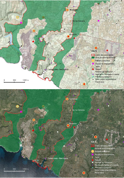
This component unfolds from the mouth of the ravines that converge on Calescoves (Biniedrís and Son Domingo), climbs up the Biniedrís ravine and reaches the smooth limestone plain of the south-east of the Migjorn, crossing two, clearly distinct landscape units. The area closest to the coast forms part of the landscape unit known as “ravines and platforms of eastern Migjorn”, while the area towards the interior of the island is included in the unit known as “plains of the Migjorn from Alaior to Maó”. The entire component part falls within the municipality of Alaior.

From the coast to the intermediate part of the area, around the village of So na Caçana, the vegetation is characterised by relatively dense wild olive forests. Next to the cliffs at the mouths of the ravines, the area presents a decidedly natural landscape in the crags, with little human alteration, bearing witness to its prehistoric vocation as funeral territory. From here, on the limestone plain, there is an excellent example of the unique Menorcan agroecosystem, with its combination of wild olive maquis, farmlands and grazing pastures enclosed in a grid of dry stone walls. This is the best-preserved example of the rural landscape of the south-east Migjorn, which also encompasses a large number of monuments and vestiges of prehistoric settlements.

As a whole, it is a very dense area in archaeological terms. 57 sites have been registered in this area of 502 ha, bearing in mind, furthermore, that some of these sites have multiple and diverse associated architectural remains around them. These include four Talayotic villages and the remains of another five smaller settlements. The settlement pattern indicates a distributed settlement, characteristic of the Eastern Migjorn plains, where there is no main population centre. It also contains nine talayots, including Torralba d’en Salort and Cotaina d’en Carreras that are laid out as nodes of the local intervisibility network.

The village of Torralba d’en Salort is one of the best-known in Menorca and, apart from the best-preserved and most spectacular taula site on the island, it also boasts two circular talayots, a hypostyle hall, a unique circular cabin from the Naviform period and an ensemble of artificial burial caves some distance away. The orientation of the taula, which was used until well into the 2nd century BC, is also exceptional, as it is one of only two cases in which these outstanding monuments of Menorca do not face south. This taula faces Sirius, the brightest star in the sky, but even so, it remains in a context of coherent relationships with all the other taulas. One striking fact is that this is one of the few places where, in a small area, there are three kinds of cyclopean construction, each representative of a different period: Naviform, Talayotic and Late Talayotic.

The So Na Caçana site, some 3 km to the south of Torralba d’en Salort, is an exceptional settlement, as it is the only one known with more than one taula enclosure (Fig. 2.a.vii.20). The site also boasts two highly unorthodox talayots, leading us to the conclusion that it is well-worthy of the consideration of a sanctuary. But it is still a village, because it contains circular houses from the Late Talayotic period. Like many prehistoric settlements of the island, it was used until after Roman times, as can be seen from the fact that it also has a small Islamic cemetery.

Close by So Na Caçana is the settlement of Torrellisar, which contains two talayots and a taula enclosure with an access that consists of a roofed corridor, built with historical dry stone walls (Fig. 2.a.vii.21). This settlement is sited in an important visual place and, as a whole, offers an interesting example of symbiosis between prehistoric cyclopean architecture and the dry stone walling works that characterise the traditional rural landscape.

The area of this component of the property contains outstanding works associated with prehistoric water engineering. These include the Na Patarrà well, set about 150 m from the village of Torralba d’en Salort, a spectacular structure and unique in the context of Mediterranean islands. Its ingenious design harnesses the natural joints in the rock, were they carved steps into the walls, forming up to nine flights of complex helical staircases.

The funeral places of this component clearly illustrate the unique traits that characterised the duality of the world of the living and the world of the dead of this culture, along with the reiterated territorial patterns. In the world of the dead, two exceptional features stand out: the spectacular funeral landscape of Calescoves and the Rafal Rubí burial navetas.

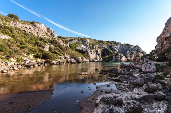
At the mouth of the Biniedrís and Son Domingo ravines is the rocky necropolis known as Calescoves, an area of exceptional landscape value that hosts a unique burial site of artificial caves in the limestone cliffs (Fig. 2.a.vii.22). This is the most extensive burial site on the island, where over 90 burial caves of very different kinds have been identified, ranging from the Naviform period, right the way up to the Late Talayotic. The Calescoves ensemble was the stage for the funeral rituals of the prehistoric communities of Menorca for almost 1,500 years, and excavations have provided many material remains, including religious artefacts and grave goods, overwhelming evidence of the universe of funeral beliefs and rituals of these prehistoric communities over the different periods. In archaeoastronomical terms, we are struck by the unique nature of the cave sanctuary of Calescoves, known as La Cova dels Jurats. Its orientation is similar to that of the taulas. But Calescoves is more than just a necropolis, there is also a fortified coastal stronghold to be found in this area, one of the few examples of settlement on the coast in this nominated property, and the underwater relics of when it was an important anchorage, as well as a small sanctuary from Roman times.

The underwater archaeological heritage is also noteworthy in this area. The boundaries of the component part include the marine area around the Calescoves anchorage. There are some important wrecks located in this marine area that hold significant material evidence illustrating trade and other relations maintained by the ancient settlers with the outside world.

There is a good representation of burial navetas in the component. The Rafal Rubí burial navetas, in the north-east corner of the component, are in strikingly good shape, and they clearly show the preference for locating these buildings in flat, concave spots, with a restricted view, such as Es Tudons. The topographic and geomorphological study of the area around the two navetas highlights their location on a slightly concave plain of modest dimensions, as the result of the surface erosion of Migjorn limestone – known in karstic geomorphology as polje – rimmed by a small limestone escarpment. This layout is very similar to the area around the Es Tudons naveta. The building of these unique tombs dates back to the Naviform period (1400 BC), and the case of Rafal Rubí represents an exceptional funeral site that includes two monumental burial navetas in a rural-natural landscape highly characteristic of the Menorcan Migjorn. Apart from these structures, there are also other chambers such as those to be found at Cotaina and Torrellisar, in this case, with a circular floor plan. Another striking aspect in the context of this component is the presence of the Biniedrís caves, the remains of which have provided evidence of the unique funeral rituals like “combing the dead”, which included dyeing the hair. This ritual has also been reported at other important sites like Cova des Carritx, where it was first identified.

alt text
Main attributes: Monuments, sites and associated landscapes
  • Torralba d’en Salort. This prehistoric village holds the privilege of hosting the best-conserved taula enclosure in Menorca, which is even more outstanding for two reasons. In archaeoastronomical terms, it represents the exception to the rule in the orientation pattern of these monuments; and in chronological terms, it is unique in that it was used for up to two centuries after the decline of the Talayotic culture of Menorca. Furthermore, it is an exceptional case in that one can find cyclopean architecture representative of all the different periods, all together, including outstanding works associated with the water culture (Criteria (iii) and (iv)).
  • Rafal Rubí. This is one of the few places on the island that can boast two burial navetas, outstanding monuments unique to Menorca, and illustrates the territorial duality between funeral and living territories that characterises the expressions of this culture (Criterion (iv)).
  • So Na Caçana. This is the only known example of a settlement with two taula enclosures and, according to the evidence, it is an exceptional case of a religious settlement (Criterion (iv)).
  • Calescoves. The Calescoves necropolis is the most extensive burial site on the Island. The many burial caves scattered around the cove and towards the interior of the ravines that comprise it include a wide diversity of different kinds, illustrating the different stages encompassed by all the periods of the island’s prehistory (Criterion (iv)). The many material finds provide a unique window onto the funeral rituals of the prehistoric communities from the Naviform until the Late Talayotic period (Criterion (iii)).
  • Associated landscape. This is the component that best represents the original relationships between the world of the living and the world of the dead in prehistoric times. These traits are still tangible in this component today (Criterion (iii)). The southern half turns into a funeral landscape, hidden inside the ravines and the cliffs at their mouths, practically unchanged since prehistoric times, while in the northern half, we see the emergence of an area representing the Menorcan agroecosystem, which illustrates a singular process of resilience of the prehistoric cyclopean landscape (Criterion (iv)).
  • Intangible attributes. This component is highly representative of the power that has emanated from the cyclopean works of the ancestors to inspire myths and legends that have formed part of Menorcan intangible culture. A good example of this is the legend of the five giants that used to meet around the taula of Torralba d’en Salort, or the myth that considered the Na Patarrà well as one of the gateways to hell (Criterion (iii)).

Protection of the component and uses of the land
75% of the listed archaeological remains in this component have been declared Heritage of Cultural Interest (BIC), including all of those mentioned in the description. The natural and landscape values of the lower part of the space, down to the coast, have been given protection within the framework of the PTIMe as ANEI (Nature Areas of Special Interest) and ANIT (Nature Areas of Interest). The rest of the area, of great traditional farming value and important landscape interest, is zoned as an AIA (Area of Agrarian Interest), except for the ribbon around the Cotaina necropolis, also considered an ANIT. The southern part, covering much of the funeral places, is included in the Natura 2000 Network. Furthermore, the review of the PTIMe (2020) reinforces the safeguarding of the component by zoning it as an Area of Landscape Interest (AIP). These land use measures guarantee the protection of the area and are fully consistent with preserving the prehistoric and landscape heritage of this component.
Component C7: South-east area - Maó (Talatí de Dalt, Torelló, Cornia Nou)
alt textDescription, location and setting
The component is located on the smooth limestone flats of the southwest of the island, in the municipality of Maó. The prehistoric monuments are sheltered by the traditional mosaic landscape comprised of thickets of wild olive, grazing land, and farmland, set in a thick grid of dry stone walls. Its state of conservation, in an area close to the city of Maó and the airport, illustrates the powerful resilience of the prehistoric cyclopean landscape up until our times, and its extraordinary survival.
Most of the component falls in the landscape unit known as “plains of the Migjorn from Alaior to Maó”. The eastern tip sticks into the unit known as “peri-urban area of Maó-Es Castell” (Cornia Nou) and exhibits the same geomorphological characteristics and land uses.

As a whole, this area is densely populated in archaeological terms. 13 sites have been catalogued in an area of 104 ha. Like Component C6, the pattern of settlement in the area indicates a relatively distributed habitat, even if we take into account the fact that villages like Talatí de Dalt and Torrelló cover an appreciable extension, over three hectares. It also contains six talayots, two per village, with the talayots of Cornia Nou, Torelló and Talatí de Dalt the ones with the highest number of visual connections in the district.

The Talayotic village of Talatí de Dalt is one of the most emblematic of the island, helped by its excellent state of conservation and harmonious blending into the surrounding rural countryside bounded by dry stone walls. This settlement can be considered exceptional for several reasons. Apart from the two talayots, it also has a unique taula with a toppled pilaster that now rests up against the lintel of the taula. This image has become one of the icons of the island (Fig. 2.a.vii.25). The settlement also includes one of the few documented spaces in Talayot villages that specialises as an independent economic zone for productive tasks, such as pottery, making tools or storage. This space is comprised of a series of covered enclosures roofed with large stone slabs, hence confirming the continuity of this technique up until the Late Talayotic period (Fig. 2.a.vii.26). Although similar to the hypostyle halls built on to the circles, which are also represented in this space, their functions are very different. Finally, the zone also conserves the remains of paving, which, to date, is the only site that has been excavated to provide evidence of urban elements of this kind in a prehistoric settlement.

The Torelló site contains remains of what was an important settlement that still conserves two talayots and the remains of a circular house from the Late Talayotic period and a water catchment system. The most striking of the two talayots is the one known as the Torelló talayot, which is the most spectacular and monumental on the island, falling into the solid-truncated cone kind with an upper floor. Together with the Cornia Nou and Torelló talayots, this site represents the initial period of this monumental type of construction. The height of this talayot gives it visual control over the whole area, from the immediate surroundings to much further afield, visually connecting with both the area of Talatí de Dalt, and with the settlements more to the east, including Cornia Nou and Trepucó.

The prehistoric settlement of Cornia Nou is set on a rise in the terrain, a sandstone platform that was used for quarrying stone for building the settlement. Smaller than the previous ones, it is home to two talayots from the beginning of the Talayotic period, characterised by the appearance of these buildings, and just when they reached the peak of their monumental nature. The western talayot, as it is known, is solid, with a truncated conic profile and attached buildings and a monumental staircase, and is one of the most paradigmatic and best-studied examples of this kind of construction and the cyclopean techniques used. Archaeological research suggests that one of the attached buildings could be considered a forerunner of the outstanding taula sites. Diggings at this village have produced a large number of vestiges of material culture (looms, bone tools, metal and stone objects) that provide abundant evidence of the use and customs of Talayotic societies.

The component contains exceptional examples of unique, prehistoric water devices, including wells, cisterns and channelling systems to feed them, especially in the villages of Cornia Nou, Talatí de Dalt and Torelló. The case of Cornia Nou is particularly relevant, as it offers good examples of storage systems from different periods, including some spectacular cisterns.

In funeral terms, the area has over a dozen hypogea, including examples of what are known as oven-shaped hypogea, from the Naviform period.

alt textMain attributes: Monuments, sites and associated landscapes
  • Talatí de Dalt. Apart from including one of the most emblematic taulas and a range of exceptional monuments not found anywhere but on Menorca, the village also hosts exceptional water works and evidence of the continued use of the unique large stone slab roofs up until the Late Talayotic period (Criterion (iv)). It has the best and most complete representation of a paved space and one that specialised in producing objects and storage that testify to the urban traits that Talayotic villages took on as they evolved (Criterion (iii))
  • Torelló. The settlement contains the Torelló talayot, the tallest and most spectacular in the Balearic Isles, and one of the best preserved, along with remains of a monumental circular house and vestiges of unique waterworks artefacts (Criterion (iv)).
  • Cornia Nou. The village, the original talayots and their associated buildings offer unique evidence of the patterns of social organisation of these communities and how they managed their agricultural produce (Criterion (iii)), and exceptional works of the unique prehistoric water culture from different times (Criterion (iv)).
  • Talayots. The talayot monuments of this component are the best representations of the initial stages of talayots, the works that marked the beginning of a great cultural transformation on the island, leading to the emergence of the Talayotic period. The first talayots are undoubtedly the most monumental and spectacular, and they bear exceptional witness to the colossal work undertaken by these people, bearing in mind the number of inhabitants and limited technical resources available (Criterion (iii)).
  • Associated landscape. The cyclopean structures are set in a well-conserved, living landscape that is representative of the traditional Menorcan agroforestry mosaic, especially in the area around Talatí de Dalt. The area is representative of the persistence of Talayotic manifestations and their associated landscapes, even in areas subject to the pressure of urban development in recent times (Criterion (iii)).

Protection of the component and land uses
46% of the archaeological remains registered in this component have been declared Heritage of Cultural Interest (BIC), including all of those mentioned in the description. Most of the component part is zoned by the PTIMe as AIA (Area of Agrarian Interest). The eastern tip (Cornia Nou), adjacent to the built-up area, is considered a Transition Area (AT). Finally, the remaining part of this area is zoned as SRG (General Regime Rustic Land). However, in this case, it is important to point out that the review of the PTIMe (2020) reinforces the safeguarding of the component by zoning it as an Area of Landscape Interest (AIP). These land-use measures, particularly the AIP, guarantee the protection of the area and they are fully consistent with preserving the prehistoric and landscape heritage of the component.
Component C8: Prehistoric village (Trepucó)
alt textDescription, location and setting
As in the case of C7, this small component part sits on a Miocene calcarenite platform typical of this part of Migjorn, in the south-east of the island. It falls within the landscape unit known as “peri-urban area of Maó-Es Castell”. This area of the component is basically the archaeological zone that contains the vestiges of the great Talayotic village of Trepucó.

Covering an area of almost 5 ha, it was one of the largest prehistoric settlements on the island, similar in extension to Torre d’en Galmés (Fig. 2.a.vii.30). What is noteworthy about this component is the excellent degree of preservation of its elements and attributes in an area that borders on the urban zone of Maó, making it a genuine reserve of prehistoric heritage. This bears witness to the attitude of Menorcan society towards their recognition and respect for these monuments. It is also a reference for some episodes of more modern history: it was the headquarters during the Franco Spanish siege of San Felipe Castle (1781- 1782), a nineteenth-century destination for local scholars and illustrious travellers and the first Menorcan site to be scientifically excavated in 1930.

The village includes two talayots. The imposing central talayot, solid style, is the broadest on the Balearic Isles. A kind of portal has been documented at the top, as well as a room with an apsidal layout. It acts as a node of visual control over the settlements around it.

The settlement also has a monumental taula enclosure, excavated in 1930 by Margaret Murray, who found large quantities of pottery, animal bones, and charcoal fragments, revealing the first evidence of the religious and functional use of these unique buildings. At almost five metres high, the taula is the tallest and most spectacular of Menorca. The settlement also contains an interesting set of Talayotic circular houses. Beyond the boundaries of the settlement, on the edge of the component, there is a burial ground where two caves with cyclopean walls have been identified.

The fact that the settlement was razed during the Second Punic War meant that it was suddenly abandoned. Because of this, when the archaeological diggings started, they brought to light a well conserved set of household items that is on display at the nearby Museum of Menorca. Here, we can find spherical buttons, lids with concentric circles, Talayot and Naviform pottery, pottery from the Roman Republic and Iberian vases, in addition to the aforementioned ritual remains. Trepucó thus becomes a privileged window onto prehistoric Menorca.


alt textMain attributes: Monuments, sites and associated landscapes
  • Taula enclosure and circular houses. The taula site of this settlement holds the tallest and most spectacular taula on the island, and the site itself is comprised of a range of circles representing these unique, exceptional monuments of Menorca (Criterion (iv)). It is also laid out as a genuine heritage reserve around the peri-urban area of Maó that has stood the test and many vicissitudes of time as an outstanding example of how these monuments have persisted throughout the history of the island (Criterion (iii)).
  • Intangible attributes. This is one of the most emblematic prehistoric settlements of Menorca; it has been famous since the 19th century. It was on the “must do” list of illustrious nineteenth-century travellers and scholars and it has both witnessed and hosted decisive events in the history of the island. It holds the title of being the first site excavated scientifically in modern times, a fact that had a decisive impact on opening up prehistoric Menorca to archaeology (Criterion (iii)).

Protection of the component and land uses
The entire area of the component is declared a Heritage of Cultural Interest (BIC) as an archaeological site. The lands on which the settlement is built, and the entire component, are zoned as General Rustic Land (SRG). But, the new review of the PTIMe (2020) enhances the safeguard of the component by zoning it as an Area of Scenic Interest (AIP). These territorial measures fully guarantee the protection of the area and they are absolutely consistent with protecting the area and with preserving its heritage, apart from the fact that a BIC is at the very top of the protection pyramid, hence, fully guaranteeing the preservation of the entire component.
Component C9: North-West area of Tramuntana (Sa Torreta, Albufera des Grau, Illa d’en Colom)
alt textDescription, location and setting
Situated in the northern half of the island, known as Tramuntana, this component encompasses part of the north-east of the island and the islet known as Illa d’en Colom. It is set on a completely different geological substrate from all the other components. Most of the terrain is comprised of Palaeozoic material (Devonian and Carboniferous), known as Dark Menorca in geological terms. In the rest, we find outcrops of fossil dunes and consolidated calcarenites from the Quaternary Era.

The vegetation that defines this landscape is also very different from the other components. Towards the interior, there is dense wild olive that can grow in thickets on the hills, in contrast with the carpet of pasture and forage crops in the depressions and on the hillsides. The coastal strip hosts coastal habitats of extraordinary interest in terms of its flora and fauna, including the presence of pine and juniper thickets and a system of coastal lagoons and wetlands.

The whole domain of this component is an extraordinarily interesting place ecologically, including Albufera des Grau. This is a wetland of exceptional importance and acts as the emblematic landscape element of the area and a fundamental landmark of the core area of the Menorca Biosphere Reserve.
The evidence indicates that the landscape around here was quite similar in prehistoric times to what we can see now, alternating between wetlands and flood plains in the lowland areas and small, cone-shaped elevations. The wetlands have disappeared elsewhere in the Tramuntana since the drainage works of recent centuries, but they are conserved to a greater extent in this component. The lower density of prehistoric occupation that can be seen in broad areas of the Tramuntana like this are obviously due to the agricultural constraints faced here for those communities, as they were communities that had to face added difficulties, which can be seen in the component in the form of a system of settlement that chose the higher areas of the terrain, away from the swampy zones.

The entire space falls within the landscape unit known as “agroforestry mosaic on Palaeozoic hills and thalwegs of Es Grau Favàritx”. In land-use terms, the interior is characterised by grazing meadows and forage crops in the non-forested areas. These are traditional activities that date back to ancient times, as can be seen from the rich ethnological and prehistoric heritage (wells, huts). The survival of this heritage is a guarantee that the scenic and ecological integrity of the area will be maintained.

As a whole, it is dense in archaeological sites, with 28 prehistoric sites registered in this area of 524 ha. Two Talayotic settlements have been documented here (Sa Torreta de Tramuntana and Morellet), together with vestiges of six other settlements, four of which are dwelling navetas. This shows that the space was occupied since the Naviform period and illustrates how cyclopean manifestations evolved over time.

Sa Torreta de Tramuntana is the largest Talayotic settlement in the north of the island (Fig. 2.a.vii.31). Situated on a high spot, it dominates much of the coast and the surrounding valleys. It boasts a talayot, a taula site, excavated in 1931 by Margaret Murray, and some vestiges of a range of circular houses. The talayot has an oval floor plan and it is tiered in a unique manner, as it is built from two superimposed parts, with a room at the top. In the case of the taula, excavations have revealed terracotta cauldrons representing the Punic god Tanit. It also has an exceptional orientation, different from the orientation pattern that characterised these outstanding cyclopean structures.

Although it was an important mining site in prehistoric times, there is no evidence of ancient settlements on the islet known as Illa d’en Colom, although the village of Morellet is close by, at a site far closer to the coast than usual for a Talayotic settlement.

The prehistoric copper mine of Mitja Lluna on Illa d’en Colom is an exceptional site, not just because of its exceptional state of conservation, but also because it is currently the only prehistoric mine known in the Balearic Isles, and one of the few that have been conserved in the south of Europe. Radio-carbon dating confirms that mining operations started in the first half of the 2nd millennium BC. Furthermore, analysis of the lead isotopes conducted on copper artefacts suggests that Sa Mitja Lluna, along with other Menorcan mines, were the main source of copper in the Balearic Isles in the 2nd millennium BC.

Funeral manifestations, always set away from the prehistoric villages, are also noteworthy in this component. To the south-east of the village of Sa Torreta, there are vestiges of a burial naveta and several hypogea and, down towards the coast, several natural burial caves.

alt textMain attributes: Monuments, sites and associated landscapes
  • Sa Torreta de Tramuntana. The best and only representation of the prehistoric settlement of the north of the island (Tramuntana), offering exceptional testimony to a process of human occupation of and adaptation to a small territory, in extreme conditions and with very few resources (Criterion (iii)). The representation in this place of unique monuments only found on Menorca takes the form of a taula enclosure, circular houses and, a certain distance away, the remains of a burial naveta (Criterion (iv))
  • Sa Mitja Lluna. This is an exceptional case for studying Bronze Age societies in the Mediterranean, especially island societies. It affords an extraordinary example of the prehistoric mining technology used, with practically no man-made alterations since prehistoric times (Criterion (iii)).
  • Associated landscape. The ensemble of archaeological sites is set in a landscape that has scarcely been altered since prehistoric times, characterised by the presence of wetlands and promontories offering highly infertile soils, bearing witness to the odyssey of prehistoric human occupation in this part of the island. In terms of landscape, the space is presided over by Albufera des Grau lagoon, now converted into the ecological gem of Menorca and one of the most important wetlands of the Mediterranean islands (Criterion (iii)).

Protection of the component and land uses
78% of the archaeological remains catalogued in this component are declared Heritage of Cultural Interest (BIC), along with all the attributes mentioned. The entire area is classed as AANP (Nature Areas of Special Interest and high level of protection). In other words, it is covered by the maximum level of territorial protection there is. The whole area forms part of the core zone of the Menorca Biosphere Reserve. Moreover, the review of the PTIMe (2020) reinforces the safeguarding of the component by zoning it as an Area of Scenic Interest (AIP) (See Chap. 5.b). Natural uses predominate in this space, interspersed with extensive farming and areas of grazing. Consequently, the protection measures and the land uses are fully in line with preserving the cultural, natural and landscape values of the component.


Vol estar informat de les darreres novetats?
Subscriu-te al butlletí
Comparteix aquest contingut
     
Consell Insular de Menorca Govern Illes Balears Unesco Menorca Reserva de Biosfera
MENORCA TALAIÒTICA - Candidata Patrimoni Mundial
Departament de Cultura i Educació - Consell insular de Menorca
Pl. Biosfera, 5 - 07703 Maó
info@menorcatalayotica.info
INICI  |  CONTACTAR  |  AVÍS LEGAL  |  XHTML 1.0  |  CSS 3  |  RSS